
The Camino Frances is a 790 km/490 mi pilgrimage route from St.Jean-Pied-de-Port in France to Santiago de Compostela in Spain. It’s the most popular Camino de Santiago route followed by the Portuguese Camino. The Camino is walked by hundreds of thousands of pilgrims every year. According to the Pilgrim’s Reception Office in 2024 236 381 people completed the route.
The Camino Frances starts in France and on its way to Santiago crosses several regions of Northern Spain; Navarra, La Rioja, Castille and Leon, and Galicia. In this post, you’ll find a detailed day-by-day itinerary of the route.
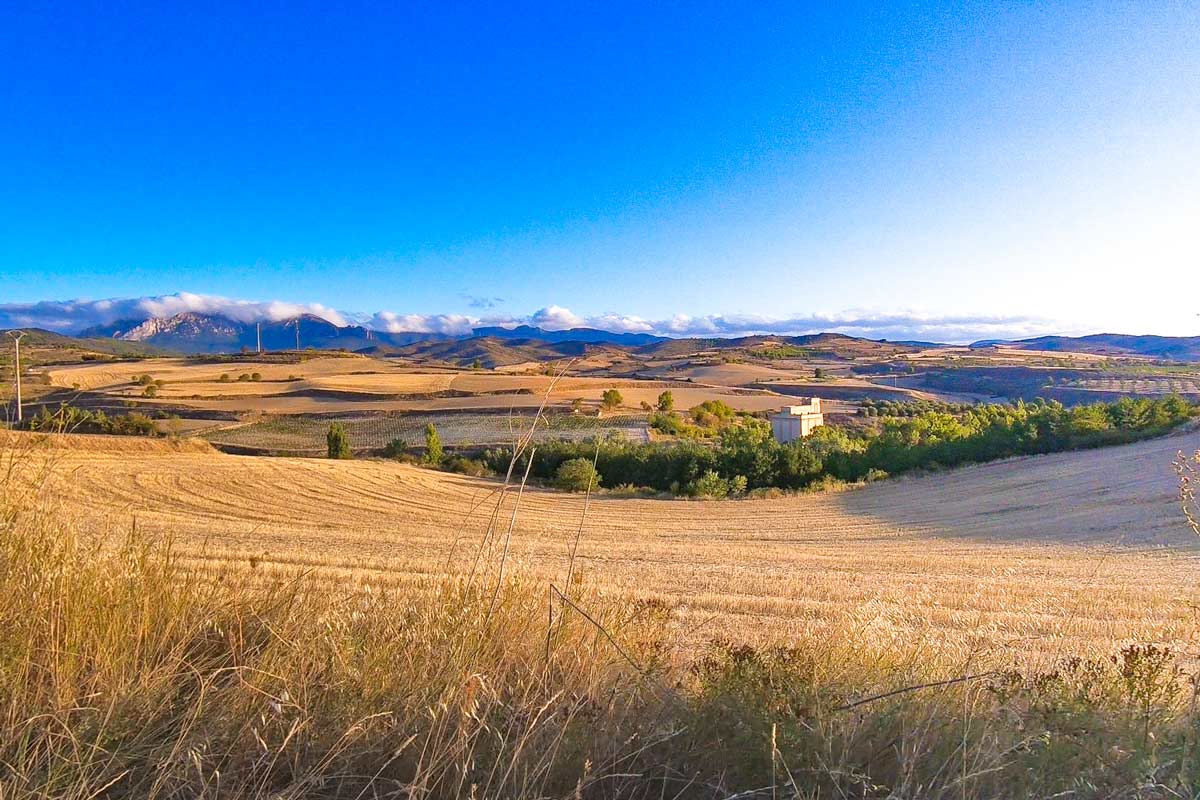
 Typical scenery on the Camino Frances
You can find all our posts on the Camino Frances on our Camino de Santiago resource page.
Table of Contents
Toggle
- Camino Frances walking stages PDF
- Camino Frances route overview
- Camino Frances GPX files
- St.Jean Pied de Port the start of the Camino Frances
- Camino Frances walking stages – a 1-month itinerary
- Stage 1. St.Jean-Pied-de-Port to Roncesvalles, 25 km/15,5 mi
- Stage 2. Roncesvalles to Zubiri, 22 km/13,6 mi
- Stage 3. Zubiri to Pamplona, 22 km/13,6 mi
- Stage 4. Pamplona to Puente La Reina, 24 km/15 mi
- Stage 5. Puente La Reina to Estella, 21,5 km/13,3 mi
- Stage 6. Estella to Los Arcos, 22 km/13,6 mi
- Stage 7. Los Arcos to Logroño, 28 km/17,3 mi
- Stage 8. Logroño to Navarrete, 12 km/6,4 mi
- Stage 9. Navarrete to Azofra, 23 km/14,2 mi
- Stage 10. Azofra to Grañon, 22 km/13,6 mi
- Stage 11. Grañon to Villafranca Montes de Oca, 28 km/17,3 mi
- Stage 12. Villafranca Montes de Oca to Cardeñuela Riopico, 24,5 km/15,2 mi
- Stage 13. Cardeñuela Riopico to Tardajos, 25,5 km/15,8 mi
- Stage 14. Tardajos to Castrojeriz, 30 km/18,6 mi
- Stage 15. Castrojeriz to Frómista, 25 km/15,5 mi
- Stage 16. Frómista to Carrión de los Condes, 20 km/12,4 mi
- Stage 17. Carrión de los Condes to Terradillos de los Templarios, 26 km/16 mi
- Stage 18. Terradillos de los Templarios to Bercianos del Real Camino, 24 km/15 mi
- Stage 19. Bercianos del Real Camino to Mansilla de las Mulas, 27 km/16,7 mi
- Stage 20. Mansilla de las Mulas to Leon, 19 km/11,8 mi
- Stage 21. León to Villar de Mazarife, 21 km/13 mi
- Stage 22. Villar de Mazarife to Astorga, 31 km/19,2 mi
- Stage 23. Astorga to Foncebadón, 26 km/16 mi
- Stage 24. Foncebadón to Ponferrada, 27 km/16,7 mi
- Stage 25. Ponferrada to Villafranca de Bierzo, 24 km/15 mi
- Stage 26. Villafranca de Bierzo to O Cebreiro, 28 km/17,3 mi
- Stage 27. O Cebreiro to Triacastela, 20 km/12,4 mi
- Stage 28. Triacastela to Sarria, 25,5 km/15,8 mi
- Camino Frances stages 29-33
- Camino Frances planning resources
- Questions or Comments?
Camino Frances walking stages PDF
We’ve created PDF files with walking stages and places to stay on the Camino Frances. You can download them for free and use them for planning your Camino walk.
Camino Frances route overview
- Total distance – 790 km/490 mi
- Number of days required – 30-34 days
- Walking surface – 290 km/180 mi – asphalt/tar; 500 km/310 mi – footpath/gravel
- Walking on the road – 70 km/43,4 mi mostly very quiet roads with almost no cars
- Accumulated ascent – 13 134 m
- Accumulated descent – 12 248 m
- Average cost – 30-35 Euros per person per day
- Accommodation – public and private albergues, hotels, guesthouses
- Route marking – yellow shells and arrows
Make sure you don’t pack too much stuff and take only necessary clothing and gear. We have a detailed Camino packing guide with tips on what to pack for men and women for different seasons.
Our YouTube video about walking the Camino Frances
Our detailed guide to the French Way of St.James contains useful information for planning the pilgrimage.
Camino Frances GPX files
You can download for free our GPX files for every stage of the Camino Frances. See how to use our GPX files for navigation on your phone.
Camino Frances walking stages GPX files
Travel insurance for the Camino
You can read more information on travel insurance for the Camino Frances in our dedicated post on Camino travel insurance or get an instant quote right now.
World Nomads travel insurance has been designed by travelers for travelers, with coverage for more than 150 activities as well as emergency medical, lost luggage, trip cancellation and more.
St.Jean Pied de Port the start of the Camino Frances
St.Jean Pied de Port has played an important role in the history of the Camino de Santiago as a gateway of the pass over the Pyrenees. It’s a beautiful town where everything is about the Camino de Santiago. France is noticeably more expensive than Spain don’t worry if everything costs more than you expected once you’re out of France prices on the Camino Frances are lower.
There are many places to stay in St.Jean including one municipal albergue that fills up quickly in the season. If you arrive after lunchtime your chances of getting a bed there are quite small.
Getting to St.Jean Pied de Port
You can get there via France or Spain. It depends on where your international flight arrives. We have a detailed explanation of how to get to St.Jean Pied de Port from both countries.
Accommodation in St.Jean Pied de Port
Booking accommodation on the Camino Frances. In the beginning, I didn’t book anything because I walked fast I always arrived early enough to get a bed but after a couple of weeks, I was pretty tired of this bed chase I started booking places. Remember, municipal albergues can’t be booked. Booking over the phone was complicated (though I speak fluent Spanish). You have to phone first to book, then a day before your booking phone again to confirm, etc. I ended up booking places through booking.com (if I could find anything suitable there) it was quick and easy.
Camino Frances walking stages – a 1-month itinerary
| Stage 1. SJPDP – Roncesvalles, 25 km/15,5 mi | Stage 2. Roncesvalles – Zubiri, 22 km/13,6 mi | Stage 3. Zubiri – Pamplona, 22 km/13,6 mi |
| Stage 4. Pamplona – Puente La Reina, 24 km/15 mi | Stage 5. Puente La Reina – Estella, 21,5/13,3 mi | Stage 6. Estella – Los Arcos, 22 km/13,6 mi |
| Stage 7. Los Arcos – Logroño, 28 km/17,3 mi | Stage 8. Logroño – Navarrete, 12 km/6,4 mi | Stage 9. Navarrete – Azafra, 23 km/14,2 mi |
| Stage 10. Azofra – Grañón, 22 km/13,6 mi | Stage 11. Grañón – Villafranca Montes de Oca, 28 km/17,3 mi | Stage 12. Villafranca Montes de Oca – Cardeñuela Riopico, 24,5 km/15,2 mi |
| Stage 13. Cardeñuela Riopico – Tardajoz, 27,5 km/17 mi | Stage 14. Tardajoz – Castrojeriz, 30 km/18,6 mi | Stage 15. Castrojeriz – Fromista, 25 km/15,5 mi |
| Stage 16. Fromista – Carrion de los Condes, 20 km/12,4 mi | Stage 17. Carrion de los Condes – Terradillos de los Templarios, 26 km/16 mi | Stage 18. Terradillos de los Templarios – Bercianos del Real Camino, 24 km/15 mi |
| Stage 19. Bercianos del Real Camino – Mansilla de las Mulas, 27 km/16,7 mi | Stage 20. Mansilla de las Mulas – Leon, 19 km/11,8 mi | Stage 21. Leon – Villar de Masarife, 21 km/13 mi |
| Stage 22. Villar de Masarife – Astorga, 31 km/19,2 mi | Stage 23. Astorga – Fonsebadon, 26 km/16 mi | Stage 24. Fonsebadon – Ponferrada, 27 km/16,7 mi |
| Stage 25. Ponferrada – Villafranca de Bierzo, 24 km/15 mi | Stage 26. Villafranca de Bierzo – O Cebreiro, 28 km/17,3 mi | Stage 27. O Cebreiro – Triacastela, 20 km/12,4 mi |
| Stage 28. Triacastela – Sarria, 25,5 km/15,8 mi | Stages 29-33. Sarria – Santiago de Compostela |
Stage 1. St.Jean-Pied-de-Port to Roncesvalles, 25 km/15,5 mi
- Distance – 25 km/15,5 mi
- Time – 6-7 hours (moving time, excluding rest stops)
- Walking surface – 14 km/8,6 mi – asphalt/tar; 11 km/6,8 mi – footpath/gravel
- Walking on the road – 3 km/1,8 mi over the pass, a very quiet road, there were one or two cars
- Ascent – 1400 m
- Descent – 650 m
- Difficulty level – 5 out of 5

 Elevation profile of day 1 on the Camino Francés. Stage from St.Jean to Roncesvalles
Highlights
- Stunning scenery; mountains, green hills, lookouts, patches of the forest if it wasn’t for the steep climb it would be a very pleasant walking day.
- Albergue Colegiata in Roncesvalles, a big and impressive old building.
- A beautiful service at the church of the Colegiata at 6pm.
Challenges
- A very long and sometimes very steep ascent, 1400 m over 21 km/13 mi
- A very steep descent, 650 m over 4 km/2,4 mi
More places to stay in Roncesvalles
Stage 2. Roncesvalles to Zubiri, 22 km/13,6 mi
- Distance – 22 km/13,6 mi
- Time – 5-6 hours
- Walking surface – 8 km/5 mi – asphalt/tar; 14 km/8,6 mi – footpath/gravel
- Walking on the road – 500 m
- Ascent – 443 m
- Descent – 871 m
- Difficulty level – 3 out of 5

 Elevation profile stage 2. Roncesvalles – Zubiri.
Highlights
- Burgette – a small town with a beautiful church
- Espinal – a small charming town with old houses, many flowers, a nice church etc.
- Zubiri – a very peaceful place with the Medieval Bridge, a small square, and a couple of small streets.
Challenges
- Many short ascents but nothing compared to the previous day
- A steep and quite long descent just before Zubiri
Place to stay in Zubiri
Stage 3. Zubiri to Pamplona, 22 km/13,6 mi
- Distance – 22 km/13,6 mi
- Time – 5 hours
- Walking surface – 11 km/6,8 mi – asphalt/tar; 11 km/6,8 mi – footpath/gravel
- Walking on the road – 1,5 km/0,9 mi
- Ascent – 405 m
- Descent – 491 m
- Difficulty level – 2 out of 5

 Elevation profile stage 3. Zubiri to Pamplona
Highlights
- A couple of charming towns along the route.
- Pamplona – one of the most beautiful cities on the Camino Frances. The Historical center is spectacular; the Cathedral, the Citadel of Pamplona, Museum of Navarra, Plaza del Castillo, etc.
- Pintxos (typical snacks) and local wines.
Challenges
- Many hills mostly at the beginning of the day
Places to stay in Pamplona

 The Historical center of Pamplona, a nice stop on the Camino Frances
Stage 4. Pamplona to Puente La Reina, 24 km/15 mi
- Distance – 24 km/15 mi
- Time – 5-6 hours
- Walking surface – 13 km/8 mi – asphalt; 11 km/6,8 mi – footpath/gravel
- Walking on the road – 500 m
- Ascent – 477 m
- Descent – 567 m
- Difficulty level – 3 out of 5

 Elevation profile stage 4. Pamplona to Puente la Reina
Highlights
- El Alto del Perdón – the famous sculpture group representing pilgrims on the Camino Frances. It’s probably one of the most famous photo spots on the route.
- A couple of nice towns with beautiful churches are on the way.
- Puente de la Reina – a picturesque town.
Challenges
- A long ascent to the Alto del Perdón with subsequent steep and rocky descents
- No shade to hide, in summer it’s better to start walking earlier.
Places to stay in Puente La Reina

 Probably the most famous monument on the Camino Francés and definitely the most photographed one.
Stage 5. Puente La Reina to Estella, 21,5 km/13,3 mi
- Distance – 21,5 km/13,3 mi
- Time – 4-5 hours
- Walking surface – 4,5 km/2,7 mi – asphalt/tar; 17 km/10,5 mi – footpath/gravel
- Walking on the road – 500 m
- Ascent – 483 m
- Descent – 437 m
- Difficulty level – 2 out of 5

 Elevation profile Camino Frances stage 5. Puente la Reina to Estella
Highlights
The Historical center of Estella; the church of Santo Sepulcro, the Convent of Santo Domingo, the Carcel Bridge, Plaza de los Fueros with a street market.
Challenges
- A couple of ascents and descents but in general an easy walking day.
Places to stay in Estella
Stage 6. Estella to Los Arcos, 22 km/13,6 mi
- Distance – 22 km/13,6 mi
- Time – 5 hours
- Walking surface – 5 km/3,1 mi – asphalt/tar; 17 km/10,5 mi – footpath/gravel
- Walking on the road – 0 km
- Ascent – 435 m
- Descent – 414 m
- Difficulty level – 2 out of 3

 Elevation profile Camino Frances, stage 6, Estella to Los Arcos
Highlights
- Wine fountain (tap) at about 3km past Estella at Bodegas Irache; one tap is with wine and another one with water.
- Rolling fields of wheat and vineyards. I walked the Camino Francés in September just before the harvest there was so much grape everywhere it was truly beautiful.
Challenges
- Nothing in particular just slight ups and downs all the way
Places to stay in Los Arcos
Stage 7. Los Arcos to Logroño, 28 km/17,3 mi
- Distance – 28 km/17,3 mi
- Time – 6-7 hours
- Walking surface – 11 km/6,8 mi – asphalt/tar; 17 km/10,5 mi – footpath/gravel
- Walking on the road – 2 km/1,2 mi
- Ascent – 488 m
- Descent – 553 m
- Difficulty level – 3 out of 5
 Elevation profile Camino Frances, stage 7, Los Arcos to Logroño
Highlights
- Olive tree plantations and vineyards – picturesque scenery and very sweet grapes.
- Viana – a beautiful town with a beautiful cathedral, cobblestone streets, many restaurants, a good place to stop for lunch.
- Just before Logroño, the Camino enters La Rioja the wine country of Spain and its smallest region.
- The historical center of Logroño; the Cathedral, several churches, Calle de San Juan (San Juan street) with hundreds of bars. I ate some delicious pintxos here, the best pintxos on the Camino Frances.

 Grape harvest is one of the advantages of walking the Camino Frances in September
Challenges
- Long walking day, the longest on the Camino Frances so far.
- Many ascents and descents in the first half of the day
- The last 5 km/3 mi of walking on asphalt is tough on your feet especially after walking more than 20 km/12,4 mi.
Places to stay in Logroño
Stage 8. Logroño to Navarrete, 12 km/6,4 mi
- Distance – 12 km/6,4 mi
- Time – 3 hours
- Walking surface – 8,5 km/5,2 mi – asphalt/tar; 3,5 km/2,2 mi – footpath
- Walking on the road – 300 m
- Ascent – 194 m
- Descent – 90 m
- Difficulty level – 1 out of 5
Highlights
- Navarrete – a small quiet town I really enjoyed staying here after bustling Logroño, it’s a perfect stop for a relaxing day on the Camino.
Challenges
- Quite a bit of walking on asphalt.
- Not many places to stop for breakfast.
Places to stay in Navarrete
Stage 9. Navarrete to Azofra, 23 km/14,2 mi
- Distance – 23 km/14,2 mi
- Time – 5 hours
- Walking surface – 7,5 km/4,6 mi – asphalt/tar; 15,5 km/9,6 mi – footpath/gravel
- Walking on the road – 500 m
- Ascent – 354 m
- Descent – 316 m
- Difficulty level – 2 out of 5

 Elevation profile stage 9 Navarrete to Ventosa
Highlights
- Walking through vineyards most of the day, there are some wineries on the way that probably do wine tasting but everything was closed in the morning.
- Nájera – a beautiful town with cobblestone streets, the Cathedral, the old bridge etc.
Challenges
- A couple of moderate ascents and descents
Places to stay in Azofra
Stage 10. Azofra to Grañon, 22 km/13,6 mi
- Distance – 22 km/13,6 mi
- Time – 5 hours
- Walking surface – 5,5 km/3,4 mi – asphalt/tar; 16,5 km/10,2 mi – footpath/gravel
- Walking on the road – 0 km
- Ascent – 400 m
- Descent – 234 m
- Difficulty level – 2 out of 5
 Elevation profile stage 10 Azofra to Grañon
Highlights
- A couple of kilometers after Grañon the Camino exits La Rija and enters Castile and León.
- The historical center of Santo Domingo de la Calzada
Challenges
- A couple of ascents and descents throughout the day.
Places to stay in Grañon
Our YouTube video on the Logroño to Burgos part of the Camino Frances
Stage 11. Grañon to Villafranca Montes de Oca, 28 km/17,3 mi
- Distance – 28 km/17,3 mi
- Time – 6-7 hours
- Walking surface – 7 km/4,3 mi – asphalt/tar; 21 km/13 mi – footpath/gravel
- Walking on the road – 0 km
- Ascent – 488 m
- Descent – 234 m
- Difficulty level – 3 out of 5
 Elevation profile Grañon to Villafranca, stage 11, Camino Frances
Highlights
- Sunflower fields though it was September and flowers were dried out but in summer it must look impressive.
Challenges
- Monotonous parts of walking along the road.
Places to stay in Villafranca-Montes de Oca
Stage 12. Villafranca Montes de Oca to Cardeñuela Riopico, 24,5 km/15,2 mi
- Distance – 24,5 km/15,2 mi
- Time – 5-6 hours
- Walking surface – 4,5 km/2,8 mi – asphalt/tar; 20 km/12,4 mi – footpath/gravel
- Walking on the road – 3 km/1,8 mi
- Ascent – 413 m
- Descent – 456 m
- Difficulty level – 3 out of 5
 Elevation profile stage 12 from Villafranca to Cardeñuela
Highlights
- First 13 km/8 mi through the forest
- A beautiful monastery and church of San Juan de Ortega
- Interesting villages; San Juan de Ortega, Agés, Atapuerta
Challenges
- 250-meter ascent right at the exit of Villafranca Montes de Oca. The first 4 km/2,4 mi of the route is up.
- Several small ascents and descents throughout the day.
Places to stay in Cardeñuela
| Municipal albergue |
Stage 13. Cardeñuela Riopico to Tardajos, 25,5 km/15,8 mi
- Distance – 25,5 km/15,8 mi
- Time – 5-6 hours
- Walking surface – 20 km/12,4 mi – asphalt/tar; 5,5 km/3,4 mi – footpath/gravel
- Walking on the road – the first 5 km/3,1 mi if you take the route through Villafría
- Ascent – 103 m
- Descent – 193 m
- Difficulty level – 3 out of 5

 The split on the Camino Frances after Orbaneja, the red route goes to Burgos following the road and past the industrial area, the right route goes along the river
Places to stay in Burgos
Highlights
- The historical center of Burgos; the cathedral is stunning from the outside and inside, I definitely recommend visiting it.
- The beginning of the famous Meseta – a long stretch of plains on the Camino Francés. For the next two weeks (basically till Astorga) the scenery will stay pretty much the same.
Challenges
- 5 km/3,1 mi of walking on the road (if you don’t take the river route).
- 8 km/5 mi of walking through the industrial area of Burgos (if you follow the main route).
- 20 km/12,4 mi of walking on asphalt. I think on the river route there will be less asphalt.
Places to stay in Tardajos
Stage 14. Tardajos to Castrojeriz, 30 km/18,6 mi
- Distance – 30 km/18,6 mi
- Time – 6-7 hours
- Walking surface – 8,5 km/5,2 mi – asphalt/tar; 21,5 km/13,3 mi – footpath/gravel
- Walking on the road – 7 km/4,3 mi very few cars
- Ascent – 331 m
- Descent – 335 m
- Difficulty level – 3 out of 5

 Elevation profile stage 14 Tardajos to Castrojeriz
Highlights
- A couple of nice towns on the way; Sambol, Hontanas
- Beautiful ruins of San Anton Monastery 4 km/2,4 mi before Castrojeriz. There is an albergue next to it for donation but it has very basic facilities (no electricity, no hot water).
Challenges
- A long walking day with few places to stop in between.
Places to stay in Castrojeriz
Stage 15. Castrojeriz to Frómista, 25 km/15,5 mi
- Distance – 25 km/15,5 mi
- Time – 5-6 hours
- Walking surface – 3 km/1,8 mi – asphalt/tar; 22 km/13,6 mi – footpath/gravel
- Walking on the road – 1 km/0,6 mi, very few cars
- Ascent – 268 m
- Descent – 281 m
- Difficulty level – 2 out of 5

 Elevation profile stage 15 of the Camino Frances, walk from Castrojeriz to Fromista
Highlights
- Can’t recall anything specific maybe a small river a couple of kilometers before Frómista.
- A couple of nice churches in Frómista
Challenges
- A steep ascent right at the beginning of the day, about 220 m up
- Not many places to stop, only two villages on the way with one bar and a couple of albergues each.
Places to stay in Frómista
Stage 16. Frómista to Carrión de los Condes, 20 km/12,4 mi
- Distance – 20 km/12,4 mi
- Time – 4 hours
- Walking surface – 10 km/6,2 mi – asphalt/tar; 10 km/6,2 mi – footpath/gravel
- Walking on the road – 6 km/3,7 mi along the road
- Ascent – 110 m
- Descent – 74 m
- Difficulty level – 1 out of 5

 The split on the Camino Frances between Frómista and Carrion de los Condes
Highlights
- A nice walk next to the river and through the fields on the alternative route
- Carrión de los Condes; Monastery Santa Clara, Church of St.Maria del Camino, Contemporary Art Museum etc.
Challenges
- The last 6 km/3,7 mi of walking along the road
Places to stay in Carrión de los Condes
Stage 17. Carrión de los Condes to Terradillos de los Templarios, 26 km/16 mi
- Distance – 26 km/16 mi
- Time – 5-6 hours
- Walking surface – 8 km/5 mi – asphalt/tar; 18 km/11 mi – footpath/gravel
- Walking on the road – 4 km/2,5 mi
- Ascent – 216 m
- Descent – 158 m
- Difficulty level – 3 out of 5
Highlights
- The main highlight was a restaurant at 17 km/10,5 mi with cold drinks and some food.
Challenges
- For the first 17 km/10,5 mi there are no towns on the Camino, make sure to take enough water. In the peak season there is a food truck at about 8 km/5 km and a small bar Oasis at 10 km/6,2 mi.
- A long and tiring day of walking through the plains with nothing around.
Stage 18. Terradillos de los Templarios to Bercianos del Real Camino, 24 km/15 mi
- Distance – 24 km/15 mi
- Time – 5 hours
- Walking surface – 4 km/2,4 mi – asphalt/tar; 20 km/12,4 mi – gravel/footpath
- Walking on the road – 500 m
- Ascent – 193 m
- Descent – 254 m
- Difficulty level – 2 out of 5

 The split on the Camino after Sahagún; the red route is the official route, the blue route is the alternative route on the Old Roman road
Highlights
- Sahagun; Church of San Tirso and Church of San Lorenzo.
Challenges
- Not many places to stop on the way, between Sahagún to Bercianos for 10 km/6,2 mi there is nothing just fields.
Albergue Bercianos 1900 is a good place to stay.
Stage 19. Bercianos del Real Camino to Mansilla de las Mulas, 27 km/16,7 mi
- Distance – 27 km/16,7 mi
- Time – 5-6 hours
- Walking surface – 2,5 km/1,5 mi – asphalt/tar; 24,5 km/15,2 mi – gravel/footpath
- Walking on the road – 500 m
- Ascent – 141 mm
- Descent – 194 m
- Difficulty level – 2 out of 5
Highlights
- Beautiful sunrise, in the Meseta if it’s not cloudy you can see the sunrise.
- Mansilla de las Mulas – a nice town with a beautiful church and a couple of restaurants.
Challenges
- Not many places to stop on the way
Places to stay in Mansilla de las Mulas
Stage 20. Mansilla de las Mulas to Leon, 19 km/11,8 mi
- Distance – 19 km/11,8 mi
- Time – 4 hours
- Walking surface – 7 km/4,3 mi – asphalt/tar; 12 km/7,4 mi – gravel/footpath
- Walking on the road – 600 m
- Ascent – 164 mm
- Descent – 140 m
- Difficulty level – 1 out of 5
In León, it’s possible to switch to the Camino Primitivo. First walk from Leon to Oviedo following the Camino de San Salvador and from Oviedo continue on the Camino Primitivo to Santiago.
Highlights
- The historical center of León; the Cathedral, the Basilica of San Isidoro, La Plaza Mayor, La Plaza San Martín, several churches.
- A Pilgrims’ Mass takes place every day in the Basilica of San Isidoro at 7pm. at the end of it, you can get a blessing and a stamp.
- Going out for tapas is another must-do activity in León, El Barrio Húmedo and El Barrio Romántico in the center are famous for their tapas bars.
Challenges
- Short parts of walking next to the road
- Walking through the outskirts of Leon (nothing bad or ugly)
Places to stay in León
Stage 21. León to Villar de Mazarife, 21 km/13 mi
- Distance – 21 km/13 mi
- Time – 4-5 hours
- Walking surface – 12,5 km/7,7 mi – asphalt/tar; 8,5 km/5,2 mi – gravel/footpath
- Walking on the road – 3 km/1,8 mi (very few cars)
- Ascent – 276 m
- Descent – 232 m
- Difficulty level – 2 out of 5

 Split on the Camino at La Virgen del Camino, 7km from León
Highlights
- Church of Virgen del Camino
Challenges
- The first 8 km/5 mi walking through the populated area of the city
Stage 22. Villar de Mazarife to Astorga, 31 km/19,2 mi
- Distance – 31 km/19,2 mi
- Time – 6-7 hours
- Walking surface – 7 km/4,3 mi – asphalt/tar; 24 km/15 mi – gravel/footpath
- Walking on the road – 0 km
- Ascent – 293 m
- Descent – 329 m
- Difficulty level – 3 out of 5
Highlights
- Hospital de Órbigo – a beautiful little town with cobblestone streets, old houses and an impressive Medieval bridge Puente del Paso Honroso.
- Villares de Orbigo
- the famous David’s place; a great stop on the route about 5km before Astorga.
- The historical center of Astorga; the Cathedral, the Gaudi Palace, the Plaza Mayor, Old Roman Walls, etc. The city is not big all the main sights are close to each other.
- My personal highlight staying at a spa hotel in Astorga, it was absolutely worth the money.
The Via de la Plata, one of the longest Camino de Santiago routes in Spain merges with the Camino Frances in Astorga.

 The main square in Astorga, one of the main towns on the Camino Frances
Challenges
- A long walking day, 31 km/19,2 mi
- A couple of ascents in the second half of the day
Places to stay in Astorga
Stage 23. Astorga to Foncebadón, 26 km/16 mi
- Distance – 26 km/16 mi
- Time – 5-6 hours
- Walking surface – 6 km/3,7 mi – asphalt/tar; 20 km/12,4 mi – gravel/footpath
- Walking on the road – 800 m (few cars)
- Ascent – 642 m
- Descent – 100 m
- Difficulty level – 3 out of 5

 Elevation profile Camino Frances stage 23, Astorga to Foncebadón
Highlights
- Rabanal del Camino – a beautiful little village
- Different from the Meseta scenery; green hills, forests, mountains.
Challenges
- A long ascent in the second half of the route, 600 m up
Places to stay in Foncebadón
Stage 24. Foncebadón to Ponferrada, 27 km/16,7 mi
- Distance – 27 km/16,7 mi
- Time – 6 hours
- Walking surface – 7,5 km/4,6 mi – asphalt/tar; 19,5 km/12 mi – gravel/footpath
- Walking on the road – 1,7 km/1 mi
- Ascent – 308 m
- Descent – 186 m
- Difficulty level – 3 out of 5

 Elevation profile stage Foncebadón to Ponferrada, Camino Francés
Highlights
- El Cruz de Ferro
- Spectacular mountain scenery during the first 10 km/6,2 mi
- A couple of small beautiful towns; El Acebo, Riego de Ambrós, Molinaseca
- The Historical center of Ponferrada; the castle, the

 Molinaseca a pretty little town on the Camino Frances
Challenges
- A steep and sometimes rocky and slippery descent for 1100 m
- Walking on the asphalt for the last 5 km/3,1 mi
Places to stay in Ponferrada
Stage 25. Ponferrada to Villafranca de Bierzo, 24 km/15 mi
- Distance – 24 km/15 mi
- Time – 5 hours
- Walking surface – 18 km/11 mi – asphalt/tar; 6 km/3,7 mi – gravel/footpath
- Walking on the road – 2 km/1,2 mi (along the road)
- Ascent – 316 m
- Descent – 351 m
- Difficulty level – 2 out of 5

 Elevation profile stage Ponferrada – Villafranca del Bierzo
Highlights
- Beautiful vineyards for the last 10 km/6,2 mi.
- Villafranca; the Collegiate Church of Santa Maria, the Convent of San Nicolás El Real, the Church of Santiago with its Puerta de Perdón (the Gate of Forgiveness) that get opened only in Holy Years.
Challenges
- The first 11 km/6,8 mi the Camino goes next to the road with the not very impressive scenery.
- Walking surface, most of the day you walk on asphalt.
Places to stay in Villafranca
Stage 26. Villafranca de Bierzo to O Cebreiro, 28 km/17,3 mi
- Distance – 28 km/17,3 mi
- Time – 7-8 hours
- Walking surface – 18 km/11 mi – asphalt/tar; 10 km/6,2 mi – gravel/footpath
- Walking on the road – 16 km/10 mi along the road with very few cars
- Ascent – 905 m
- Descent – 138 m
- Difficulty level – 4 out of 5

 Elevation profile stage Villafranca del Bierzo to O Cebreiro
 Two route options on the Camino Frances after Villafranca; the official route (red) and the mountain route (blue).
Highlights
- Many small villages along on the way; Trabadelo, La Portela de Valcarce, Las Herrerías, La Faba etc.
- Stunning views on the way from Las Herrerías up to O Cebreiro.
- Beautiful scenery from the viewpoint in O Cebreiro.

 Stunning view from O Cebreiro, Camino Frances
Challenges
- A lot of walking on asphalt and along the road.
- A very steep and long ascent, about 700 m over the last 6 km/3,7 mi, the ascent starts at 21 km/13 mi after Las Herrerías. One of the toughest days on the Camino Frances.
Places to stay in O Cebreiro
Stage 27. O Cebreiro to Triacastela, 20 km/12,4 mi
- Distance – 20 km/12,4 mi
- Time – 5 hours
- Walking surface – 2 km/1,2 mi – asphalt/tar; 18 km/11 mi – footpath/gravel
- Walking on the road – 0 km
- Ascent – 305 m
- Descent – 1063 m
- Difficulty level – 3 out of 5

 Elevation profile of the walk from O Cebreiro to Triacastela
Highlights
- Great views on the way down from O Cebreiro
Challenges
- Several ascents and descents in the beginning
- A long and steep descent to Triacastela
Places to stay in Triacastela
Stage 28. Triacastela to Sarria, 25,5 km/15,8 mi
- Distance – 25,5 km/15,8 mi
- Time – 6 hours
- Walking surface – 11 km/6,8 mi – asphalt/tar; 14,5 km/9 mi – gravel/footpath
- Walking on the road – 6 km/3,7 mi, quiet road, not many cars
- Ascent – 210 m
- Descent – 320 m
- Difficulty level – 2 out of 5
Highlights
- An incredible Galician forest 5 km/3,1 mi past Triacastela, a very peaceful walk with no towns, roads or people.
- The Monastery of Samos – a big beautiful complex. If you have time it’s worth visiting the church.

 Impressive monastery of Samos, Camino Frances
Challenges
- A long stretch in the beginning right after Triacastela along the road, about 4 km/2,4 mi but there were practically no cars.
Places to stay in Sarria
Camino Frances stages 29-33
A detailed itinerary for the last 5 stages of the Camino from Sarria to Santiago de Compostela can be found in our post “Walking the Camino Frances from Sarria“. As an option after finishing in Santiago, you can continue walking to Finisterre, it’ll take 3-4 more days.
Camino Frances planning resources
Questions or Comments?
Got any questions or comments? We would love to help! All questions and comments will be answered by us personally in Buy Me a Coffee. Click below and ask away.
Feel free to support our site by buying us a coffee!


The pretty half of Stingy Nomads, responsible for all our land adventures (hiking, climbing, walking the Camino) and following them write-ups. Alya loves walking since she was a child, she prefers to walk 1000 km with a backpack rather than to do a 10 000 km road trip (actually any road trip). Alya is a big fan of Latin America, the Spanish language, and dancing. Every time we go away she desperately misses our dog Chile.
Източник за тази статия
Наши спонсори са:
Български трактори на добри цени при изключително качество