
The Fishermen’s Trail in the Algarve region, in the south of Portugal is a part of the Rota Vicentina hiking routes. The trail follows the coastline and offers breathtaking scenery; rugged cliffs, pristine beaches, and crystal clear water, it’s a perfect route for those who like the sea and outdoor activities. The route can be walked as a separate trek or combined with the Historical Way of the Rota Vicentina. The hike is one of the most beautiful hiking trails in the Algarve.
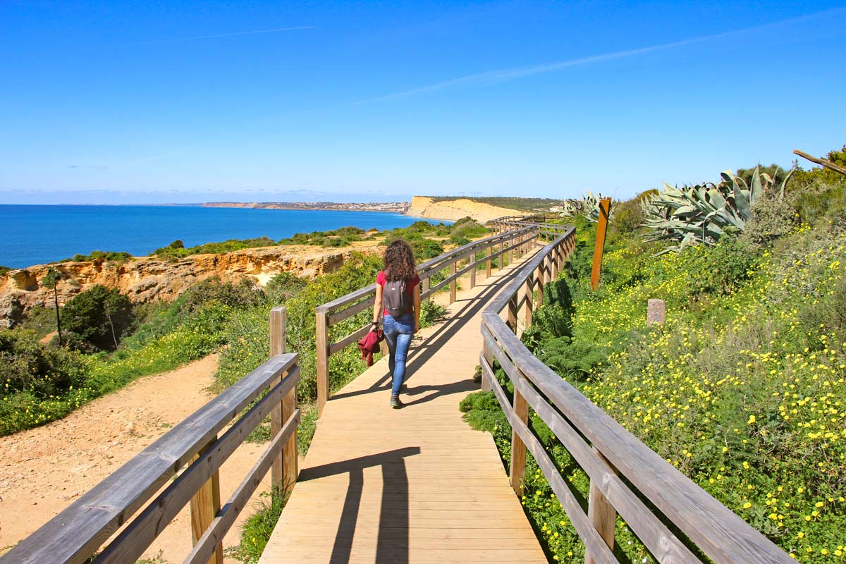
 Alya walking on a boardwalk at Ponta da Piedade in Lagos
Fishermen’s Trail walking itinerary PDF
To help you with planning your walk we created a free downloadable PDF file with the Fishermen’s Trail itinerary. The file contains walking stages and a list of accommodation options on the Fishermen’s Trail of the Rota Vicentina.
For more details on the trail including the cost of walking, route options, transportation, and luggage delivery service read our detailed guide to the Fisherman’s Trail.
Our YouTube video on the Fishermen’s Trail
Fishermen’s Trail GPX files
You can download our GPX files for each day on the Fishermen’s Trail and use them on your device during the hike. The files are the property of Stingy Nomads. They are for personal use only, no commercial use is allowed.
Fishermen’s Trail GPX files
A detailed guide on How to use Stingy Nomads GPX files to navigate with your phone.
The Fishermen’s Trail Overview
- Distance – 230 km/143 mi
- The required time – 12 days or less; any section of the trail can be walked as a separate hike
- Total ascent (over 12 days) – 4418 m
- Total descent – 4414 m
- Starting point – Porto Covo or S.Torpez Beach
- Finishing point – Lagos
- Walking surface – a mix of soft sand (dunes, beaches) and footpath with parts on the gravel road.
- Route marking – blue & green markers
- Average cost – from 30 Euro per person per day
- Accommodation – campsites, hostels, guesthouses
The Fishermen’s Trail is not the only long-distance walking route near Lisbon. If after walking along the coast you’d like to hike through a different area you can walk one of the pilgrimage routes that start in Santiago e.g. the Portuguese Camino from Lisbon.
Travel insurance for the walk
If you’re wondering how much travel insurance for your trip will cost you can get an instant quote right now.
World Nomads travel insurance has been designed by travelers for travelers, with coverage for more than 150 activities as well as emergency medical, lost luggage, trip cancellation and more.
Porto Covo, the beginning of the Fishermen’s Trail
The Fishermen’s Trail was extended. Now its official start is at Kalux Bar, S.Torpes Beach, 10 km north of Porto Covo. We walked that stretch later. I don’t see much of a point in this route extension. The trail starts in the middle of nowhere at a thermal power station, halfway between Sines and Porto Covo. It’s not the most picturesque part of the trail. Most of the route goes along the road. I say it’s up to you to decide to start at S.Torpes Beach or in Porto Covo.
Porto Covo is a nice town, one of our favorite towns on the Fishermen’s Trail. It’s small and cozy; cobblestone streets, two-story houses with red roofs, and the main square with many restaurants and bars. It has a great holiday vibe.
If you arrive in the morning you can start walking the same day but I recommend spending a night in Porto Covo.
Ahoy Porto Covo Hostel
Ahoy Porto Covo Hostel is a great place to stay for hikers. Nicolau, the owner, knows a lot about the trail, he is better informed than the people at the information office. We got some useful tips, recommendations, and a map of the trail with some marks on it. The hostel is often fully booked so it’s better to book it in advance.
More places to stay in Porto Covo
The Fishermen’s Trail – a 12-day itinerary
Day 1. Porto Covo – Vila Nova de Milfontes, 19 km/11,8 mi
- Distance – 19 km/11,8 mi
- Time – 5h10min.
- Ascent – 278 m
- Descent – 292 m
- Difficulty level – 3 out of 5 it was a short walking day but most of the time you walk on dunes sometimes ankle-deep in the sand.

 Elevation profile of the first day on the Fishermen’s Trail. The walk from Porto Covo to Vila Nova de Milfontes. As you can see it’s very flat with barely any hills
It was an incredible walking day on the Fishermen’s Trail. The route goes along the coast or on the beach with stunning views from the cliffs. The water temperature was about 17 °C a bit cold to go for a swim but nice to walk in ankle-deep water. Make sure to take enough water with. Walking on sand makes you tired and thirsty. You’ll need at least 1,5l of water per person. There were a couple of amazing beaches on the way.

 A map of the trail from Porto Covo to Vila Nova de Milfontes
Highlights
- Many unspoiled sandy beaches; Praia da Ilha do Pessegueiro, Praia dos Aivados, Praia do Saltinho, Praia dos Nascedios, Praia do Malhao. Every time we got a chance we took off our shoes and walked barefoot on the beach, basically first 10 km you can walk on the beach.
- Wildflowers along the trail (we walked the Fishermen’s trail in May).
- A couple of stork nests on the edges of the cliffs.
The entire walk was one big highlight we loved it despite the tough part of walking on sand.
Challenges
- As I already mentioned walking on sand was quite difficult, our shoes were full of it, and it didn’t help to shake it out because it got in immediately.
- No place to stop for food or water for 16 km after the restaurant at Praia da Ilha do Pessegueiro.
Stops on the route
- At 3,5 km at Forte do Pessegueiro, there is a restaurant
Vila Nova de Milfontes
This town is bigger than Porto Covo. The center of the town is nice with traditional white houses with blue, red and yellow color doors and windows. The big part of the town is hotels it wasn’t the season yet the place was very quiet. There is a nice fortress Forte de Sao Clemente and a couple of beaches in the town.
- Hotel/guesthouse – yes
- Hostel – yes
- Campsite – yes
- ATM – yes
- Restaurant – yes
- Supermarket/shop – yes
- Pharmacy – yes
- Beach – yes
Places to stay in Vila Nova de Milfontes

 The main street of Porto Covo, the beginning of the Fishermen’s Trail
Day 2. Vila Nova de Milfontes – Almograve, 16 km/10 mi
- Distance – 16 km/10 mi
- Time – 4h15min.
- Ascent – 204 m
- Descent – 192 m
- Difficulty level – 1 out of 5, a short and easy walking day on the footpath with some sandy parts.

 Elevation profile of the route from Vila Nova de Milfontes to Almograve
The route goes through Vila Nova following Rua Custodio Bras Pacheco (the main street in the town) from your hotel you just can get to this street and continue following the signs on the left-hand side of the street. The first 4 km was not very scenic; out of the town, along the road, across the bridge to the other side, and then through the bush back to the coast. You can easily skip it and take a boat.
Alternative! In Vila Nova de Milfontes you can take a boat to the other side of the river instead of walking across the bridge. it’ll make your walking day about 4 km shorter. You won’t miss out a lot, the first 4 km were through the town and along the road. I’d rather spend that time enjoying the beach. The boat leaves as soon as they have enough people. The pier is at the fortress. The boat drops you at the beach on the opposite side. You don’t have to look for the trail just continue walking along the beach to Ocean Drive Beach restaurant.
Praia das Furnas is a great place to stop, the trail goes past the beach but we recommend going down and walking on the beach. After Praia das Furna the trail goes on and off the coast through forests and fields. At about 3,5 km before Almograve, there is a split; the left route goes inland, the right route goes back to the coast. Both routes join in Almograve.
I recommend taking the coastal route it’s more scenic and takes you past three beautiful beaches, though we missed the split and took the inland route.

 A map of the section of the Fishermen’s Trail from Vila Nova de Milfontes to Almograve
Highlights
- Several spectacular beaches along the route; Praia das Furnas, Praia dos Picos, Praia da Angra.
- Stunning views from the cliffs, rugged coastline, and fields covered in flowers.
Challenges
- 1,5 km of walking on the road from Vila Nova de Milfontes across the bridge to the other side of the river. You can skip this part by taking a boat.
- No places in between to stop for food and water. Make sure to have enough water and some snacks. There was a bar at Praia das Furnas at about 5 km but it was closed (maybe because it was Monday).
Stops on the route
- At 5 km at Praia da Furnas, there is a restaurant.
Almograve
- Hotel/guesthouse – yes
- Hostel – yes
- Campsite – no
- ATM – yes
- Restaurant – yes
- Supermarket/shop – yes
- Pharmacy – yes
- Beach – yes, about 500 m away
A very small town much smaller than Vila Nova, about 500 km away from the beach. There are a couple of restaurants on the main square and several guesthouses.
Places to stay in Almograve

 Campbell on the beach close to Vila Nova de Milfontes
Day 3. Almograve – Zambujeira do Mar, 22,5 km/14 mi
- Distance – 22,5 km/14 mi
- Time – 5h45min.
- Ascent – 293 m
- Descent – 274 m
- Difficulty level – 2 out of 5

 Elevation profile of the trail from Almograve to Zambujeira do Mar
There are two options to walk out of the town; the first route goes to the beach, the second one goes inland. Both routes merge after about 1 km. We took the beach option, this route goes past the church and left through the bush to the beach. After about 1 km at the parking spot, the official route goes inland but it’s possible to walk on the beach Praia da Longueirinha for about 500 m and then go upstairs back to the trail. It’s the only place on the route for the whole day where you can get to the beach so don’t miss this opportunity. For the rest of the day, you can enjoy the stunning sea scenery but have no chance to get close to the water.
For the first 10 km, the route goes over the dunes you walk in deep sand. After the small town of Cavaleiro most of the time, you walk on the gravel road.

 A map of the walking trail from Almograve to Zambujeira do Mar
Highlights
- Breathtaking views from the trail; the sea, small beaches, rugged coast, cliffs, etc.
- Cabo Sardao – a beautiful cape and a lighthouse.
- Many storks nests on the edges of the cliffs. The best area for spotting storks was at 18 km/11 mi just before Entrada do Barca, there were some nests with babies that you could come pretty close to.
- Stunning views from the cliffs just before Zambujeira.
Challenges
- First 10 km/6,2 mi on the dunes
- A short stretch of boring walking along the road past Entrada do Braca, for about 1,5 km.
Stops on the route
- At 10 km/6,2 mi Cavaleiro; two restaurants, a shop, hotels, and a bus stop
- At 19 km/11,8 mi Entrada do Barca; two restaurants
Zambujeira do Mar
- Hotel/guesthouse – yes
- Hostel – yes
- Campsite – yes
- ATM – yes
- Restaurant – yes
- Supermarket/shop – yes
- Pharmacy – yes
- Beach – yes
Another small town, a bit bigger than the previous one, with many restaurants and guesthouses. There are a couple of nice beaches around the town.
Places to stay in Zambujeira do Mar

 The lighthouse at Cabo Sardao on the way to Zambujeira do Mar
Day 4. Zambujeira do Mar – Odeceixe, 19 km/11,8 mi
- Distance – 19 km/11,8 mi
- Time – 4h50min.
- Ascent – 403 m
- Descent – 423 m
- Difficulty level – 2 out of 5, a couple of short ascends and descends, here and there some sandy parts.

 Ascents and descents on the Fishermen’s Trail from Zambujeira do Mar to Odeceixe
From the beginning to about 4 km/2,4 mi before the end, the route goes next to the ocean so incredible views are guaranteed. The walk has a bit more ascents and descents than the previous days but nothing tough. The last 4 km/2,4 mi to Odeceixe is along the road with the river on one side and green hills on the other side, not as stunning as the rest of the day but still beautiful. Just before Odeceixe, the Fishermen’s Trail crosses from the Alentejo region to the Algarve.

 A map of the stage of the Fishermen’s Trail from Zambujeira do Mar to Odeceixe
Highlights
- Praia dos Alterinhos – an unspoiled beach right after Zambujeira with a cave (at the end of the beach) and interesting rock formations, the only beach on the route for the day.
- Breathtaking views along the trail; rugged cliffs, pristine beaches, pine forest, fields of flowers
- Praia de Odeceixe – a stunning view over the beach.
Challenges
- Walking in deep sand from time to time
- A couple of steep but short ascents
Stops on the route
- At 3 km/1,8 mi Praia do Carvalhal there is a coffee shop.
- At 10 km/6,2 mi Azenha do Mar – a tiny village with a restaurant
Odeceixe
- Hotel/guesthouse – yes
- Hostel – yes
- Campsite – yes
- ATM – yes
- Restaurant – yes
- Supermarket/shop – yes
- Pharmacy – yes
- Beach – yes, about 3 km/1,8 mi away at Praia de Odeceixe
Its the first town on the trail that is not by the sea. The beach is about 3 km away. Odeceixe is the place where both Rota Vicentina routes; the Fishermen’s Trail and the Historical Way join.
If you prefer to stay closer to the beach you can walk 3 km/1,8 mi extra to Praia de Odeceixe, a tiny place with a couple of hotels and restaurants at the beach. You can see it from the cliffs. It’s on the opposite side of the river, at low tide it’s possible to walk across the river close to the sea, it still might be about knee-deep. If the crossing is impossible you’ll have to walk first to Odeceixe and then back to the beach, it’s a 6 km/3,7 mi loop.
Places to stay in Odeceixe
Day 5. Odeceixe – Aljezur, 23 km/14,2 mi
- Distance – 23 km/14,2 mi*
- Time – 5h30min.
- Ascent – 288 m
- Descent – 280 m
- Difficulty level – 2 out of 5
*if you don’t do the Odeceixe beach circuit and follow the inland route the total distance is 18 km/11 mi

 Elevation graph of the Fishermen’s Trail from Odeceixe to Aljezur
From Odeceixe there are two route options on the Fishermen’s Trail; one is to continue inland, this route is 5 km/3,1 mi shorter; another option is to walk past Odeceixe Beach to the coast. This route is a bit longer but you get to see the sea and the beautiful Praia do Odeceixe.

 A route map of the walking trail from Odeceixe to Aljezur
Highlights
- Incredible scenery on the coastal route.
Challenges
- Occasional walking on the road, here and there but not for long and the road is not busy.
Stops on the route
- At 3,5 km/2,1 mi Praia de Odeceixe; restaurants, hotels
- At 14,5 km/9 mi Rogil (11 km/6,8 mi if walking inland); a supermarket, restaurants, hotels, ATMs
Aljezur
- Hotel – yes
- Hostel – yes
- Campsite – yes, 3 km before the town on the route
- ATM – yes
- Restaurant – yes
- Supermarket/shop – yes
- Pharmacy – yes
- Beach – no
A nice town, bigger than Odeceixe with several accommodation options, many restaurants, and bars, about 5 km/3,1 mi away from the sea. If you’re planning to camp the campsite is 3 km/1,8 mi before the town, on the Fishermen’s Trail.
Places to stay in Aljezur

 Praia de Odeceixe is one of the most spectacular beaches on the Fishermen’s Trail
Day 6. Aljezur – Praia da Arrifana, 19 km/12 mi
- Distance – 19 km/12 mi or 12 km/7,4 mi*
- Time – 4h35min.
- Ascent – 418 m
- Descent – 362 m
- Difficulty level – 3 out of 5 with a couple of steep ups, in the beginning, 4-5 km of walking through the sand in the second half
*At 4,5 km/2,7 mi there is a split; one route is shorter with a total distance of 12 km/7,4 mi, and it continues inland. The second route goes to the coast, which offers great scenery but it’s longer, the total distance 19 km/12 mi.

 Elevation profile of the Fishermen’s Trail from Aljezur to Arrifana
Note! You can skip Arrifana and walk directly from Aljezur to Carrapateira it’s a long walk, about 31 km/19,2 mi.
We thought it was going to be a short walking day but it wasn’t because we took the coastal route which was 6 km/3,7 mi longer but the scenery was worth it. The very beginning of the route for about 3 km/1,8 mi after the split is not that spectacular you walk through the countryside but once you reach the coast it gets better. If you have time, go down to the beach, enjoy the swim, drink a cup of coffee, and then continue. It’s the only place to stop for food or drinks on the way.
The last 3 km/1,8 mi to Arrifana is through the pine forest on a sandy footpath the scenery is not as impressive as along the coast but still quite nice.

 A map of the Fishermen’s Trail from Aljezur to Arrifana
Highlights
- Praia de Monte Clerigo – a beautiful beach with a couple of restaurants and cafes
- On the coastal route stunning views from the cliffs, rugged coastline, and several pristine beaches
- Praia da Arrifana
Challenges
- In the beginning, a couple of steep ascents and descents
- On the coastal route 4 km/2,4 mi of walking on the sand
Stops on the route
- At 11 km/6,8 mi (coastal route) Praia de Monte Clerigo; a restaurant, coffee shop, hotel
Praia da Arrifana
- Hotel – yes
- Hostel – yes
- Campsite – no
- ATM – no
- Restaurant – yes
- Supermarket/shop – yes 2-3 km away
- Pharmacy – no
- Beach – yes
When you book a place in Arrifana make sure it’s located in the town, the place is very small, there are many guesthouses around but some of them are located 3 km/1,8 mi away from the beach and the trail.
More places to stay in Praia da Arrifana

 Sunset from the cliffs at Arrifana Beach
Day 7. Arrifana – Carrapateira, 20 km/12,4 mi
- Distance – 20 km/12,4 mi
- Time – 4h30min.
- Ascent – 555 m
- Descent – 619 m
- Difficulty level – 3 out of 5 many ascents and descents

 Elevation profile of the Fishermen’s Trail the Arrifana to Carrapateira sections
It was a nice walking day though in the afternoon it got quite hot. Make sure to refill your water at every stop and put on sunscreen you are exposed to the sun for the whole day. After about 2 km/1,2 mi you get to the coast it’s the only time today when the route comes that close to the sea till the end of the day you walk inland from time to time you can see the ocean from far.
If you have time you can do a detour and walk to the beach before heading to Carrapateira, the town is about 2 km/1,2 mi away from the sea.

 A map of the walking trail from Arrifana to Carrapateira, Fishermen’s Trail
Highlights
- Praia do Canal, a small beach at 2 km/1,2 mi with beautiful views from the cliffs.
- Green hills, vineyards, and flowers for most of the day.
- Many cork oaks along the road. The tree is Portugal’s national tree, we did see them before on the route but not as many as here.
- Praia da Bordeira is a long sandy beach about 2 km/1,2 mi before Carrapateira. It’s one of our favorite beaches on the Fishermen’s Trail.
Challenges
- A couple of quite steep ascents and descents, and no shade to hide on a hot and sunny day
Stops on the route
- At 8 km/5 mi a guest house/restaurant (was closed when we were there on Saturday afternoon).
- At 9,5 km/6 mi Nomad Surfers hostel and restaurant – a great place to stop.
- At 18 km/11 mi Bordeira is a small town with a couple of guest houses and restaurants.
Carrapateira
- Hotel – yes
- Hostel – yes
- Campsite – no
- ATM – no
- Restaurant – yes
- Supermarket/shop – yes
- Pharmacy – no
- Beach – yes, 3 km away
It’s a small town about 3 km/1,8 mi away from the sea.
Places to stay in Carrapateira

 Boardwalks leading to a lookout point at the Carrapateira Beach
Day 8. Carrapateira – Vila do Bispo, 15 km/9 mi
- Distance – 15 km/9 mi
- Time – 4 hours
- Ascent – 504 m
- Descent – 430 m
- Difficulty level – 4 out of 5, several steep ascents and descents

 Elevation profile of the route from Carrapateira to Vila do Bispo
Despite the short distance, the Carrapateira to Vila do Bispo stage is quite challenging due to several steep ascents and descents.
The first 1,7 km/1 mi from Carrapateira are inland. Between 1,7 km/1 mi and 8,5 km/5,2 mi, the trail goes along the coast past several beaches. It offers spectacular views from the top of the cliffs. Sometimes the trail goes on the edge of the cliffs.
There are several steep ascents and descents to the top of the cliffs and down to the beach between 3,5/21, mi km and 8 km/5 mi. From 8,5 km/5,2 mi the route continues inland through the plains. In spring the fields are covered in flowers. In summer/fall it looks dry and dusty.

 A map of the walking route from Carrapateira to Vila do Bispo
Highlights
- It is a short but demanding walking day with spectacular coastal scenery in the first 8 km/5 mi.
Challenges
- Several steep ascents and descents. If you walk it in summer make sure you have enough water it gets very hot.
- A very steep and long ascent with a subsequent descent between 7,4 km/4,5 mi and 8 km/5 mi.
- No place to stop for food or drinks between 2,5 km/1,5 mi (Amado Beach) and 15 km/9 mi (Vila do Bispo).
Stops on the route
- 1,7 km/1 mi – a restaurant
- 2,5 km/1,5 mi – Amado Beach, restaurants, toilets
Vila do Bispo
- Hotel – yes
- Hostel – no
- Campsite – no
- ATM – yes
- Restaurant – yes
- Supermarket/shop – yes
- Pharmacy – yes
- Beach – no
Vila do Bispo is a very quiet town with many new houses, a couple of restaurants along the main street, and a big supermarket, it doesn’t look like a typical holiday town.
Places to stay in Vila do Bispo

 Amado Beach from the top of the cliffs
Day 9. Vila do Bispo – Sagres, 21 km/13 mi
- Distance – 21 km/13 mi*
- Time – 4h50min.
- Ascent – 282 m
- Descent – 313 m
- Difficulty level – 2 out of 5
*If you don’t feel like walking 6 km/3,7 mi from Cabo de S.Vicente to Sagres you can take a shuttle bus.

 Elevation profile of the route from Vila do Bispo to Sagres, Fishermen’s Trail
From Vila do Bispo the Fishermen’s Trail goes past the market towards the sea. For the first 6 km/3,7 mi you walk through the fields. At about 6 km/3,7 mi there is a split; one route goes to the coast, another continues inland. The coastal route is marked with green and blue stipes, the inland route is marked with red and white. The distance on both routes is about the same, 14 km/8,6 mi.
From the Cape of St.Vincent , you can walk to Sagres or take a bus. The walk is along the coast next to the road. The bus ride takes 10 min. You can check the up-to-date itinerary on the Vamus Algarve website. The bus stops in Sagres and then continues to Lagos making stops in Vila do Bispo, Salema, and Burgau.
The Fishermen’s Trail used to finish in Sagres but it was extended to Lagos a couple of years ago.

 A map of the Fishermen’s Trail from Vila do Bispo to Sagres
Highlights
- If you take the coastal route there are some stunning views from the cliffs over the sea and the beaches. The scenery on this day reminded me of the scenery on the Seven Hanging Valleys Trail in Southern Algarve.
- Cabo de S.Vicente – a cape with a lighthouse and a fortress and impressive scenery.
Challenges
- The walk from Cabo de S.Vicente to Sagres is mostly along the road though the scenery is still beautiful.
Stops on the way
- At 14 km/8,6 mi Cabo S.Vicente there are a couple of food stalls.
Sagres
- Hotel – yes
- Hostel – yes
- Campsite – yes, 2 km outside the town
- ATM – yes
- Restaurant – yes
- Supermarket/shop – yes
- Pharmacy – yes
- Beach – yes
A small beach town with a couple of nice beaches, good surf spots, many hotels, and restaurants.
Places to stay in Sagres

 The lighthouse at Cabo de São Vicente near Sagres
Day 10. Sagres – Salema, 20 km/12,4 mi
- Distance – 20 km/12,4 mi
- Time – 5-6 hours
- Ascent – 533 m
- Descent – 555 m
- Difficulty level – 5 out of 5

 Elevation profile of the walking stage from Sagres to Salema
After completing the Fishermen’s Trail I can say that the Sagres to Salema walk is one of the most challenging stages.
In Sagres, the route starts at the tourist information office near Mareta Beach. It goes across the town following the main street (Rua Cmte Matoso) which is not the most picturesque way. Instead, you can do a loop along the cliffs from Mareta Beach past the Ponta da Atalaya viewpoint to the harbor. It adds 2,5 km/1,5 mi to your total distance. The views of the coast and the beaches from the cliffs are breathtaking. You can get back to the official Fishermen’s Trail at Pinóquio Cafe.

 The map of the alternative route along the cliffs in Sagres
The trail follows the coast for most of the day except for two stretches at 2,7 km/1,6 mi (for about 4 km/2,4 mi) and 13,5 km/8,3 mi (for about 3 km/1,8 mi) when it turns inland. The first half of the walk is pretty easy with a couple of ascents and descents on the top of the cliffs past beautiful beaches.
I suggest stopping for lunch at one of the restaurants at 10 km/6,2 mi at Ingrina Beach or at 10,7/6,6 mi km at Zavial Beach.
The second half of the route is more challenging especially if you walk it in summer. Make sure you have enough water. You can buy more water at the restaurants. From Praia das Furnas which is at 13,5 km/8,4 mi you start going up and down non-stop till you reach Salema. In Salema, the stage finishes at the beach.

 The map of the Sagres to Salema stage of the Fishermen’s Trail
Highlights
- Views of Mareta Beach, Sagres Fortress, and the coast from the top of the cliffs (if follow the alternative route along the coast).
- Many spectacular beaches along the route: Martinhal Beach, Barranco Beach, Ingrina Beach, Zavial Beach, and Praia das Furnas.
- The beautiful coastal town of Salema with a picturesque beach.
Challenges
- Multiple steep ascents and descents with loose rocks in the second half of the day.
Stops on the way
- At 10 km/6,2 mi Ingrina Beach there is a restaurant that accepts only cash, closed on Tuesdays.
- At 10,7 km/6,6 mi Zavial Beach there is a restaurant, closed on Mondays.
Salema
- Hotel – yes
- Hostel – no
- Campsite – yes, outside the town
- ATM – yes
- Restaurant – yes
- Supermarket/shop – yes
- Pharmacy – yes
- Beach – yes
Places to stay in Salema

 Zavial Beach is one of the highlights of the Sagres to Salema stage of the Fishermen’s Trail
Day 11. Salema – Praia da Luz, 12 km/7,4 mi
- Distance – 12 km/7,4 mi
- Time – 3-4 hours
- Total ascent – 409 m
- Total descent – 420 m
- Difficulty level – 3 out of 5
The last 2 stages of the Fishermen’s Trail are short. You can combine them and walk from Salema to Lagos. The total distance will be 22,5 km/14 mi.

 Elevation profile of the walk from Salema to Praia da Luz
Salema to Praia da Luz is a beautiful walk along the coast with some breathtaking views from the cliffs. The first part from Salema to Burgau I enjoyed the most. There are not too many people on the trail, and the scenery is stunning. The second half from Salema to Praia da Luz is busier and through more developed areas. There are houses and villas pretty much all the way from Salema to Luz. The scenery is still beautiful.
For the entire 12 km/7,4 mi, the route follows the coast you almost always see the sea and the beaches. The water in this part of the Algarve is a bit warmer than on the West Coast. You can stop on the way for a quick swim and relax on the beach.

 A map of the fishermen’s trail from Salema to Praia da Luz
Highlights
- Boca do Rio Beach is a beautiful unspoiled beach
- Almadena Fort – ruins of an old fort on the top of the cliffs with fantastic views
- Almadena Beach – a long sandy beach surrounded by cliffs
- Praia das Cabanas Velhas – a small hidden beach with a restaurant
- Burgau – a cozy town with a picturesque beach
- Praia da Luz is a charming beach town crazy busy in the summer and very quiet outside of the season.
Challenges
- Several short but sometimes steep ascents and descents
Stops on the way
- At 6,5 km/4 mi Burgau, a small beach town with several restaurants and cafes.
Praia da Luz
It’s a charming little town with many cafes and restaurants. We come here quite often especially outside of the summer months when the beach is empty.
- Hotel – yes
- Hostel – yes
- Campsite – no
- ATM – yes
- Restaurant – yes
- Supermarket/shop – yes
- Pharmacy – yes
- Beach – yes
Places to stay in Praia da Luz

 Cabanas Velhas Beach, Fishermen’s Trail
Day 12. Praia da Luz to Lagos, 10,5 km/6,4 mi
- Distance – 10,5 km/6,4 mi
- Time – 2h30min. – 3 hours
- Ascent – 251 m
- Descent – 254 m
- Difficulty level – 2 out of 5

 Elevation profile of the last stage of the Fishermen’s Trail from Praia da Luz to Lagos
The walk from Praia da Luz to Lagos is one of our favorite parts of the Fishermen’s Trail. Probably because we live in Lagos and often walk it as a day hike. The route takes hikers to some of the highlights of the area such as Porto de Mos Beach, Ponta da Piedade, Camilo Beach, Done Ana Beach, etc.
The beginning of the trail is the most challenging part with a long and steep ascent to the top of the cliffs. It’s the part of the route with fewer people. The views from the top are spectacular. From Porto de Mos Beach the route goes through a quiet neighborhood of Lagos to Ponta da Piedade. I would recommend spending some time there and going to the lookout points some of them offer fantastic views.
If you have time stop at Camilo Beach. This hidden beach with a long staircase is one of the most picturesque beaches in Lagos. After Dona Ana Beach follow the trail on the top of the cliffs. The views from there are great.
The official end of the Fishermen’s Trail is at the train station in Lagos. You don’t have to walk all the way there and after Dona Ana Beach can head straight to your accommodation place in Lagos.

 A map of the walking route from Praia da Luz to Lagos
Highlights
- Rocha Negra, a cliff with a lookout point
- Porto de Mos Beach, one of the best beaches in Lagos
- Ponta da Piedade, a picturesque cape with several lookout points, boardwalks, and a lighthouse
- Camilo Beach, is a small hidden beach with a long staircase
- Dona Ana Beach
- Old Town of Lagos
Challenges
- A long and steep ascent from Praia da Luz to the top of the cliff with a subsequent descent to Porto de Mos Beach.
Stops on the way
- At 4 km/2,4 mi Porto de Mos Beach with a couple of restaurants
- At 8 km/5 mi Camilo Beach with a restaurant
- At 9 km/5,5 mi Dona Ana Beach with a couple of restaurants
Places to stay in Lagos
If you decide to stay for a couple of days in Lagos to enjoy its beautiful beaches and relax after the hike send us a message so we can meet up for coffee or drinks. We live in Lagos and love meeting people who share our passion for hiking and the outdoors.

 Stunning scenery at Ponta da Piedade at the end of the Fishermen’s Trail
Recommended books and guidebooks
Fishermen’s Trail planning resources
Questions or Comments?
Got any questions or comments? We would love to help! All questions and comments will be answered by us personally in Buy Me a Coffee. Click below and ask away.
Feel free to support our site by buying us a coffee!
LIKE THIS POST? PIN IT!


Travel bloggers from South Africa
Източник за тази статия
Наши спонсори са:
Български трактори на добри цени при изключително качество